Environmental Monitoring

Environmental Monitoring Sensors
Mark Camello
Latest posts by Mark Camello (see all)

Introduction to Environmental Monitoring

Definition and Importance

Environmental monitoring is the systematic collection and analysis of environmental data to observe changes, trends, and impacts over time. This practice allows scientists, policymakers, and concerned citizens to track the health of our planet, detect pollution sources, and enforce environmental regulations. It includes tracking air quality, water safety, soil conditions, and biodiversity to ensure a sustainable balance between nature and human activity.

Think of environmental monitoring like a fitness tracker—but for the Earth. Just as we monitor our heartbeat, sleep cycles, or calorie intake, environmental monitoring tracks the Earth’s vital signs. When something goes out of balance—like a spike in air pollution or a drop in groundwater levels—it serves as an early warning system. The goal is to catch issues before they spiral into environmental disasters.

Environmental monitoring plays a vital role in protecting ecosystems, ensuring public health, and guiding industries toward eco-friendly practices. With increased global awareness around climate change, environmental degradation, and natural resource depletion, the relevance of environmental monitoring has skyrocketed. Data collected from these systems can inform legislative decisions, alert populations about hazardous conditions, and even fuel climate activism. It bridges the gap between raw data and real-world action.

Moreover, businesses and urban planners rely on this data for sustainable development. Imagine a construction company starting a new project near a wetland—without proper monitoring, the delicate ecosystem could be disrupted. But with detailed environmental data, construction can be planned in harmony with nature. Ultimately, environmental monitoring is not just about protecting nature—it’s about ensuring that we can continue living safely and sustainably within it.

Historical Background and Evolution

Environmental monitoring might feel like a new buzzword, but its roots trace back to ancient civilizations. The Romans, for instance, noticed the effects of lead poisoning long before the term “pollution” even existed. However, formal environmental monitoring began to take shape in the 20th century, largely as a response to industrialization and the visible consequences of pollution.

In the 1960s and 70s, catastrophic environmental events like the Great Smog of London and the Cuyahoga River catching fire pushed governments to acknowledge the urgent need for environmental regulations. This period saw the birth of several environmental protection agencies and the development of monitoring systems. The Clean Air Act (1970) and Clean Water Act (1972) in the United States, for instance, mandated systematic monitoring to ensure compliance.

The technological evolution has been staggering. Early monitoring tools were basic—mostly manual sampling and lab testing. Fast forward to today, and we have drones scanning forest canopies, satellites tracking methane leaks from space, and smart sensors streaming real-time air quality data to mobile apps. This tech revolution has not only made monitoring more precise but also more accessible.

Global collaboration also took center stage. The formation of the Intergovernmental Panel on Climate Change (IPCC) in 1988 marked a pivotal moment in standardized global environmental monitoring. Since then, countless data-sharing platforms, research collaborations, and environmental treaties have emerged to foster international cooperation. Today, environmental monitoring is not just a government responsibility—it’s a global movement driven by science, technology, and community participation.


Types of Environmental Monitoring

Air Quality Monitoring

Air quality monitoring involves measuring pollutants in the atmosphere such as carbon monoxide (CO), sulfur dioxide (SO2), nitrogen dioxide (NO2), ozone (O3), and particulate matter (PM2.5 and PM10). With urbanization and industrial activities on the rise, air quality monitoring has become a front-line defense for public health.

Imagine living next to a busy highway without knowing how much pollution you’re inhaling every day. Air quality monitoring stations placed around cities and industrial areas provide real-time data that helps government bodies issue warnings, enforce regulations, and even determine “no car” days during smog peaks.

Technologies involved include gas analyzers, optical sensors, and mobile air monitoring units. Today, wearable air monitors and smartphone-compatible sensors are even empowering individuals to track their immediate environment. The data gathered feeds into environmental dashboards used by health departments and urban planners to improve air quality strategies.

The significance of air monitoring extends beyond human health—it also affects climate. Certain air pollutants, like black carbon and ground-level ozone, contribute directly to global warming. Monitoring these helps in crafting climate policies and evaluating the effectiveness of emission reduction measures. Air quality indices (AQIs) have become a daily part of our lives, especially in major metropolitan cities, making air quality monitoring one of the most visible and impactful forms of environmental oversight.


Water Quality Monitoring

Water is life—but contaminated water is a silent killer. Water quality monitoring ensures that our rivers, lakes, oceans, and groundwater are safe for drinking, recreation, and agricultural use. It measures parameters like pH levels, dissolved oxygen, turbidity, biological oxygen demand (BOD), chemical contaminants (pesticides, heavy metals), and pathogens.

Consider a rural community that relies on a nearby river for drinking water. Without consistent water quality checks, they risk exposure to diseases like cholera, dysentery, or arsenic poisoning. Monitoring programs help prevent such disasters by identifying pollution sources early—whether it’s industrial discharge, agricultural runoff, or untreated sewage.

Modern tools like spectrophotometers, sensors, drones, and even AI-powered buoys now make water monitoring more efficient. These technologies can scan for pollutants, alert authorities, and recommend corrective actions in real-time.

Water monitoring is also crucial in conservation. Aquatic ecosystems are incredibly sensitive to changes in water chemistry. A slight shift in pH can wipe out entire fish populations. That’s why organizations like the Environmental Protection Agency (EPA) invest heavily in routine water sampling and data modeling. It’s not just about safe drinking water—it’s about maintaining the planet’s intricate web of life.


Soil Monitoring

Soil isn’t just dirt—it’s the foundation of life. Soil monitoring tracks its physical, chemical, and biological properties to ensure it remains fertile, non-toxic, and structurally sound. Parameters include nutrient content (nitrogen, phosphorus, potassium), pH levels, moisture content, salinity, and presence of heavy metals or pollutants.

Soil degradation affects food security, biodiversity, and even water cycles. Over-farming, deforestation, and industrial waste disposal are major culprits behind declining soil health. Regular soil monitoring helps detect these issues early, allowing corrective actions like soil amendment, crop rotation, or reforestation.

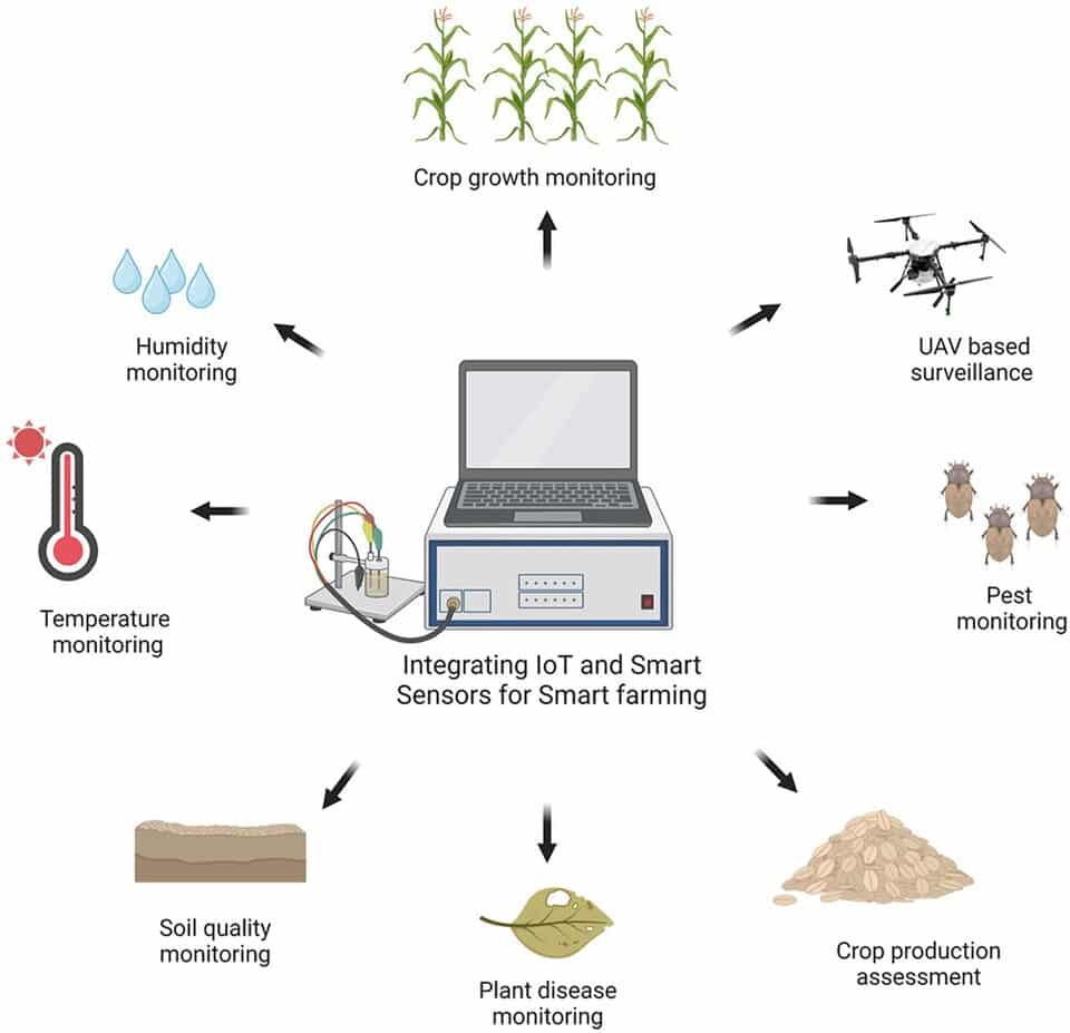
Farmers use soil data to make decisions on fertilizers, irrigation, and crop choice—transforming traditional farming into smart agriculture. Governments use it for zoning, infrastructure development, and environmental risk assessments. Soil monitoring is also key in post-disaster recovery, especially after floods or industrial spills, where soil contamination can linger for years.

Today, satellite imagery and geospatial tech allow large-scale soil assessments, while portable soil kits empower local communities and schools to get involved. It’s a quiet yet powerful way to protect the Earth from the ground up.


Biodiversity Monitoring

Biodiversity monitoring focuses on tracking the variety and variability of life within ecosystems, including plants, animals, fungi, and microorganisms. This type of monitoring serves as a barometer for ecosystem health, helping researchers and conservationists understand how species interact with each other and their environment.

Let’s put it in perspective: imagine a forest. A healthy forest isn’t just about trees—it’s about the birds, bugs, fungi, and even bacteria in the soil. If certain species begin disappearing or migrating, it’s a red flag that something’s wrong—maybe climate change, pollution, or habitat loss. That’s where biodiversity monitoring becomes essential.

Methods include wildlife camera traps, bioacoustic monitoring (like listening to bird calls or frog croaks), satellite tracking, and environmental DNA (eDNA) testing. These tools help identify species presence, behavior, migration patterns, and population health without needing to capture or disturb them.

Governments and NGOs use biodiversity monitoring to implement protective measures like creating reserves or adjusting hunting and logging regulations. It also plays a crucial role in global biodiversity targets like the Aichi Biodiversity Targets or the Post-2020 Global Biodiversity Framework.

On a grassroots level, citizen science projects like bird-watching counts or butterfly surveys bring local communities into the fold. These efforts aren’t just educational—they also provide massive datasets that would be impossible for scientists to gather alone.

Biodiversity monitoring isn’t just about saving pandas or polar bears. It’s about preserving the delicate balance that makes life on Earth possible.


Key Components of an Environmental Monitoring System

Sensors and Equipment

At the core of every environmental monitoring system lies a set of tools designed to detect and record environmental conditions. These range from simple pH meters to advanced multi-parameter sensors and spectrometers. The choice of sensors depends on what you’re monitoring—air, water, soil, or biodiversity.

For air quality, sensors might detect gases like carbon monoxide, nitrogen dioxide, or ozone. Water sensors often measure temperature, turbidity, dissolved oxygen, and contaminants like lead or mercury. Soil sensors track moisture levels, salinity, and nutrient content.

Modern sensors are often part of automated systems that don’t require manual intervention. They can be solar-powered, wireless, and built to withstand harsh environments. Some even have self-cleaning mechanisms or can be remotely calibrated, reducing maintenance costs and human error.

Drones and UAVs (unmanned aerial vehicles) equipped with sensors and cameras are increasingly popular in environmental surveys, especially in hard-to-reach places like dense forests, wetlands, or mountainous regions. These allow high-resolution mapping and data collection with minimal ecological disturbance.

Choosing the right equipment is critical. Faulty sensors can result in inaccurate data, which leads to misguided decisions. That’s why calibration, validation, and regular servicing of equipment are non-negotiable parts of any serious monitoring program.


Data Collection and Transmission

Once environmental data is detected by sensors, the next step is collecting and transmitting that data efficiently and securely. In earlier days, this meant manual logbooks and periodic lab testing. Today, real-time data transmission is the norm, thanks to digitalization.

Most modern systems use wireless technologies like Wi-Fi, Bluetooth, LoRaWAN, or cellular networks to send data to central databases or cloud storage. In remote areas, satellite communication is often used.

Data loggers play a key role in storing time-stamped environmental readings, especially in areas where real-time transmission isn’t feasible. These are later retrieved manually or wirelessly synced to central systems.

The Internet of Things (IoT) has revolutionized this process. Sensors embedded in everything from air filters to river buoys can now communicate with each other, creating interconnected networks that provide a more holistic view of the environment. This interconnectivity enables predictive maintenance, instant alerts, and even automatic corrective actions in some systems.

One challenge, however, is data overload. With so much incoming data, ensuring its integrity, relevance, and accuracy is vital. Efficient data handling frameworks and protocols must be in place to prevent corruption or loss of data during transmission.


Data Analysis and Reporting

Raw environmental data is just the beginning. The real power lies in how that data is interpreted, visualized, and acted upon. This is where data analysis and reporting come into play.

Advanced software platforms crunch the numbers, detect trends, and flag anomalies. These platforms often use algorithms and machine learning models to predict environmental changes, such as rising pollution levels or imminent algal blooms.

For example, a sudden spike in nitrogen dioxide readings in a city might indicate a traffic congestion issue. Coupled with weather data and traffic patterns, analysts can pinpoint the source and recommend interventions like traffic rerouting or temporary emissions restrictions.

Visualization tools, including GIS maps and dashboards, make it easier for non-experts like policymakers or the general public to understand complex data. Clear, concise reports often include charts, color-coded maps, and infographics for instant readability.

Transparency in reporting is essential. Publicly accessible environmental reports build trust, encourage community involvement, and push industries toward accountability. On the policy level, this data helps enforce environmental laws, set new standards, and monitor compliance.

In short, data analysis is the bridge between environmental facts and actionable insights.


Technologies Used in Environmental Monitoring

Satellite and Remote Sensing

Satellites offer a bird’s-eye view of Earth’s environmental status, from deforestation and desertification to ocean temperatures and glacier retreats. Remote sensing refers to the technique of collecting data from a distance, usually via satellites or aircraft, using sensors that detect reflected or emitted energy.

These technologies are invaluable in large-scale environmental monitoring. Imagine trying to measure deforestation across the Amazon using only ground teams—it would be nearly impossible. But satellites can cover vast areas in minutes, providing up-to-date, high-resolution images.

Remote sensing tools can detect temperature changes, chlorophyll levels in oceans (a sign of algae), or even methane leaks from oil fields. Platforms like NASA’s Landsat or the European Space Agency’s Sentinel satellites have been instrumental in global environmental assessment.

Data from these sources feeds into climate models, disaster response systems, and even agricultural planning tools. They allow us to track changes over time, compare them to historical baselines, and anticipate future trends.

Moreover, with open-access satellite data becoming more common, even small research teams and developing countries can tap into these powerful tools for local and regional monitoring.


IoT and Smart Sensors

The Internet of Things (IoT) is making environmental monitoring smarter, faster, and more responsive. IoT involves a network of interconnected devices—each collecting, sharing, and responding to data. In the environmental context, these could be air quality monitors on streetlights, water sensors in rivers, or soil probes in farms.

The key advantage? Real-time decision-making. Let’s say a river’s water level rises dangerously after a storm. An IoT sensor can detect the change and immediately alert disaster management authorities, potentially saving lives and property.

Smart sensors can also reduce energy use, alert users to maintenance needs, and integrate with apps for personal alerts (like high pollen counts or poor air quality days). They are widely used in smart cities, precision agriculture, and industrial pollution control.

As technology advances, these devices are becoming more energy-efficient, cost-effective, and user-friendly—making large-scale deployment more feasible than ever before


Geographic Information Systems (GIS)

Geographic Information Systems (GIS) are the unsung heroes of environmental monitoring. These systems collect, manage, and analyze spatial and geographic data to visualize environmental patterns across both time and space. Think of GIS as a digital map on steroids—it doesn’t just show you where things are, it shows what’s happening there, how it’s changing, and what might happen next.

GIS is used to map deforestation, monitor urban sprawl, analyze soil erosion, track wildlife migration, and even predict flood risks. It’s essential for identifying trends and making data-driven decisions. For example, GIS can combine rainfall data with elevation models to forecast landslides. Or it can overlay pollution maps with population density to find vulnerable communities.

The beauty of GIS lies in its ability to handle vast datasets from diverse sources—satellite images, field surveys, drone footage, sensor data—and present them in a single, interactive platform. This holistic view is invaluable for researchers, environmental agencies, urban planners, and even farmers.

What’s more, GIS data can be updated in real-time and shared across agencies and countries, enhancing collaboration and global environmental stewardship. Many platforms now offer mobile-friendly versions, allowing field agents to collect and upload data on the go.

As environmental challenges become more interconnected and complex, GIS will continue to be a cornerstone technology in monitoring and managing the Earth’s changing face.


Artificial Intelligence and Machine Learning

Artificial Intelligence (AI) and Machine Learning (ML) are reshaping how we monitor and respond to environmental changes. These technologies excel at identifying patterns in massive datasets and making predictions that help guide environmental management strategies.

Imagine thousands of air quality sensors deployed across a city. AI can analyze this avalanche of data, detect pollution hotspots, predict smog events, and even recommend traffic flow changes to reduce emissions. Similarly, ML algorithms are used to detect illegal logging in satellite imagery or identify endangered species through camera trap photos.

One of the most exciting applications is predictive analytics. AI models can forecast droughts, flood risks, or disease outbreaks based on past and current data. These early warnings are crucial for governments, farmers, and communities to prepare and respond proactively.

AI also enhances automation. In water treatment plants, for instance, AI can control chemical dosing based on real-time water quality data, ensuring safety and efficiency without human intervention.

Furthermore, AI-powered drones and robots are being used in marine and terrestrial environments to collect data, monitor habitats, and even clean pollution. These smart systems save time, reduce risk, and cover areas that are hard for humans to reach.

In essence, AI and ML aren’t replacing human expertise—they’re amplifying it, helping us understand our environment faster, deeper, and more accurately than ever before.


Applications of Environmental Monitoring

Urban Planning and Development

Environmental monitoring plays a pivotal role in shaping sustainable cities. Urban planners use environmental data to make informed decisions about where and how to build. From identifying flood-prone zones to measuring urban heat islands, monitoring ensures that development doesn’t come at the cost of environmental degradation.

Let’s say a city wants to expand its public transportation system. Monitoring data can show which areas suffer the most from air pollution or noise, guiding where new transit routes could relieve congestion. Similarly, monitoring soil stability can influence decisions on building high-rises or underground infrastructure.

Green spaces, zoning laws, waste management systems—all benefit from reliable environmental data. Real-time air and noise sensors can even trigger adaptive responses like dimming streetlights or redirecting traffic to reduce pollution.

Cities also rely on environmental monitoring to comply with regulations and attract eco-conscious investments. Smart city initiatives often integrate environmental sensors into traffic lights, public buildings, and water systems to continuously optimize resource use.

In short, environmental monitoring helps urban areas grow smarter, greener, and more livable.


Industrial and Agricultural Sectors

Industries and farms are both significant contributors to environmental change—and some of the biggest beneficiaries of monitoring technology. Monitoring helps them reduce waste, increase efficiency, and comply with environmental regulations.

In agriculture, monitoring soil moisture, temperature, and nutrient levels enables precision farming. Farmers can apply water and fertilizers only where needed, cutting costs and minimizing runoff that pollutes nearby water bodies. Monitoring also helps in pest detection, crop health assessment, and irrigation control.

Industries, on the other hand, use environmental monitoring to manage emissions, treat wastewater, and control chemical storage. Sensors placed in smokestacks, effluent outlets, or chemical tanks ensure that pollutants stay within legal limits. Real-time data allows rapid response to potential hazards, preventing costly fines or environmental disasters.

Moreover, transparent monitoring builds public trust and aligns companies with sustainability goals. Environmental compliance isn’t just a legal requirement—it’s increasingly a brand value. Companies that can demonstrate their green credentials through hard data gain a competitive edge.

Whether it’s a farm using drones to analyze crop patterns or a factory reducing its carbon footprint, environmental monitoring is becoming a vital part of operational excellence.


Climate Change Research

Perhaps the most critical application of environmental monitoring today is in the realm of climate change. Monitoring data helps scientists track the Earth’s changing systems—rising temperatures, shifting precipitation patterns, melting glaciers, and increasing sea levels.

Climate models rely on accurate, long-term data sets collected through monitoring systems. These models forecast future climate scenarios, helping policymakers develop strategies to mitigate and adapt to climate change.

For instance, monitoring ocean acidity and temperature helps predict coral bleaching events. Tracking carbon dioxide concentrations in the atmosphere helps evaluate the effectiveness of emissions-reduction policies. Ice core samples, satellite imagery, and tree-ring analysis all offer historical climate insights that inform our understanding of current trends.

Monitoring also plays a role in climate justice. By identifying which regions are most affected—like small island nations or Arctic communities—resources can be allocated more fairly. Monitoring even supports international agreements like the Paris Accord by verifying whether countries are meeting their climate pledges.

Without monitoring, we’d be flying blind into the storm. With it, we have a chance to steer toward a more sustainable future.


Public Health and Safety

Environmental monitoring is a powerful tool in safeguarding human health. Pollutants in the air, water, or soil can lead to a range of health problems—respiratory illnesses, cancers, developmental issues, and more. Monitoring helps detect these hazards early and guide preventive measures.

Air quality monitoring, for example, allows cities to issue alerts during high pollution days, urging vulnerable populations to stay indoors. Water monitoring ensures that drinking water is safe and free from pathogens or toxins. Even noise pollution monitoring plays a role in reducing stress-related illnesses and improving quality of life.

In industrial zones, monitoring systems detect hazardous leaks or chemical spills, triggering emergency responses. In disaster-prone areas, sensors measure soil moisture and seismic activity to warn of landslides or earthquakes.

Public health agencies also use environmental data to track disease outbreaks. Rising temperatures and stagnant water bodies, for instance, can be early indicators of dengue or malaria risk. By correlating environmental data with health records, authorities can predict and prevent epidemics.

Ultimately, environmental monitoring bridges science and safety—keeping us informed, prepared, and protected.


Challenges in Environmental Monitoring

Data Accuracy and Reliability

Accurate data is the foundation of effective environmental monitoring. However, achieving high data reliability is far easier said than done. Even minor sensor malfunctions or environmental interference can skew results, leading to flawed interpretations and misguided policy decisions.

For instance, temperature sensors might overheat in direct sunlight, giving falsely high readings. Similarly, air quality sensors can be affected by humidity or dust, especially in urban or industrial settings. Calibration errors, faulty installation, or poor maintenance can all compromise the integrity of collected data.

Moreover, inconsistent data collection methodologies across regions or agencies make it difficult to compare or combine datasets. What one country records as “acceptable pollution levels” might not match another’s standards, causing confusion in international collaborations.

Another challenge is temporal reliability. Environmental conditions fluctuate constantly, so infrequent data collection can miss critical spikes or patterns. For example, a monthly water test might miss a one-day chemical spill that causes significant damage.

Overcoming these issues requires investment in high-quality sensors, regular calibration schedules, standardized protocols, and trained personnel. Quality control mechanisms and data validation algorithms also play a vital role in ensuring that the final output is both reliable and actionable.


Cost and Infrastructure Limitations

Environmental monitoring systems, particularly those involving sophisticated technologies like satellites, IoT networks, or AI-based analytics, can be prohibitively expensive. This is a major barrier for many developing countries or rural regions that lack the financial and infrastructural resources.

Setting up a comprehensive monitoring network involves upfront capital for equipment, ongoing operational costs, training for technical staff, and maintenance. In remote areas, even basic electricity and internet connectivity may be lacking, making real-time monitoring nearly impossible.

These limitations often result in monitoring gaps—regions where little or no environmental data is collected. This makes it harder to develop inclusive, global strategies for climate change, biodiversity conservation, or pollution control.

To bridge the gap, international aid, public-private partnerships, and community-based initiatives are essential. Open-source software, affordable sensors, and mobile data collection apps have also emerged as cost-effective alternatives. Still, there’s a long way to go before environmental monitoring becomes universally accessible and equitable.


Policy and Regulatory Barriers

Even when data is accurate and infrastructure is in place, policy barriers can limit the effectiveness of environmental monitoring. In many regions, outdated regulations, lack of enforcement, or bureaucratic red tape prevent timely action on environmental issues.

For example, a country might have strict air quality standards on paper, but without the legal mandate to penalize violators, industries continue polluting unchecked. In other cases, government agencies may hoard environmental data for political reasons or economic interests, blocking transparency and public awareness.

There’s also the challenge of integrating environmental monitoring into existing policy frameworks. Policymakers often operate on short election cycles, while environmental changes unfold over decades. This disconnect leads to reactive, rather than proactive, governance.

Furthermore, inter-agency coordination is often lacking. Environmental data might be scattered across departments—forestry, agriculture, urban planning—without a centralized system for analysis and decision-making.

Reforming these barriers requires political will, cross-sector collaboration, and strong civil society engagement. Legal frameworks must evolve to not only support monitoring but to act swiftly based on its findings.


Global Environmental Monitoring Programs and Agencies

United Nations Environment Programme (UNEP)

The UNEP is one of the leading international organizations involved in environmental monitoring and protection. Established in 1972, it works with governments, NGOs, and scientists worldwide to track global environmental trends and implement sustainable solutions.

UNEP’s Global Environment Outlook (GEO) reports are renowned for synthesizing data from thousands of monitoring systems to provide a comprehensive state-of-the-planet assessment. These reports influence international policy and are often used as references in climate negotiations and environmental treaties.

The UNEP also runs several initiatives like the Global Environment Monitoring System (GEMS), which tracks water quality, and collaborates with regional agencies to expand environmental data access in under-resourced areas.


World Health Organization (WHO)

Though primarily focused on health, the WHO plays a crucial role in environmental monitoring through its Air Quality and Health Unit. The organization maintains global databases on air pollution and water safety, linking environmental factors to public health outcomes.

The WHO’s guidelines on safe exposure levels for pollutants are widely adopted by countries as benchmarks. It also supports nations in developing their own monitoring capacities through funding, technical assistance, and training programs.

By highlighting the direct link between environmental quality and human health, the WHO strengthens the case for urgent and sustained monitoring efforts.


National and Local Government Initiatives

Around the world, countries and cities are developing their own environmental monitoring programs tailored to local conditions. In the U.S., the Environmental Protection Agency (EPA) operates extensive networks for air and water monitoring. In India, the Central Pollution Control Board (CPCB) runs a nationwide air quality index.

Local governments are also stepping up. Smart cities like Singapore, Amsterdam, and Copenhagen use real-time environmental data to drive green urban policies. They install air quality monitors on streetlights, use sensor data to optimize waste collection, and deploy smart water systems to detect leaks and contamination.

Decentralized, localized monitoring empowers communities to take control of their environments, promoting sustainable practices from the ground up.


Case Studies and Success Stories

Clean Air Initiatives in Europe

Several European cities have successfully used environmental monitoring to tackle air pollution. London, for instance, installed thousands of air quality monitors to enforce its Ultra Low Emission Zone (ULEZ), significantly reducing nitrogen dioxide levels.

Paris uses data from sensors to implement car-free days when pollution peaks, while Berlin has adopted real-time dashboards to inform residents of current air quality and adjust traffic patterns accordingly.

These initiatives demonstrate how real-time monitoring, when coupled with proactive policy, can deliver measurable environmental benefits.


River Clean-up Projects in Asia

India’s Ganga River clean-up mission is one of the most ambitious environmental projects globally. Real-time water monitoring stations were installed along the river’s course to detect contamination, enforce industrial compliance, and guide clean-up efforts.

In China, the Yangtze River Protection Law mandated rigorous water quality monitoring that led to the shutdown of hundreds of polluting factories. Japan’s efforts in Tokyo Bay have also shown success, using monitoring data to gradually restore marine ecosystems affected by industrialization.


Forest Monitoring in South America

Brazil’s use of satellite monitoring to track Amazon deforestation is a powerful example of technology in action. Programs like PRODES and DETER analyze satellite imagery in near real-time, enabling authorities to detect illegal logging and take swift action.

These systems have not only helped slow deforestation but have also built international pressure and accountability. Other countries like Peru and Colombia are adopting similar models to protect their own rainforest territories.


Future of Environmental Monitoring

Emerging Technologies

The future of environmental monitoring is driven by innovation. Quantum sensors, blockchain for data integrity, autonomous monitoring robots, and biodegradable sensor materials are just a few of the technologies on the horizon.

As these technologies mature, they will make monitoring more affordable, precise, and widely deployable. Integration with AI, cloud computing, and 5G will enable near-instant data processing and decision-making.

This evolution is especially important in the face of climate change, where rapid responses are often the difference between safety and catastrophe.


Community-Based Monitoring Initiatives

Citizen science and community-based monitoring are reshaping how data is collected. From farmers checking rainfall with smartphone apps to school children measuring air quality, these grassroots efforts are filling in the gaps left by traditional systems.

Organizations like Earthwatch and SciStarter offer platforms where anyone can contribute to environmental data collection. This democratization not only expands monitoring reach but also raises awareness and fosters a sense of responsibility.

The future lies in collaboration—where governments, tech innovators, and everyday citizens unite to monitor and protect our shared home.


Role of Citizen Science

Citizen science turns passive observers into active participants. With mobile apps, cheap sensors, and online databases, anyone can collect and share data on local air quality, water purity, noise levels, or biodiversity.

These contributions are invaluable. They help build hyper-local datasets, identify blind spots, and push authorities to act. Plus, involving citizens increases transparency, combats misinformation, and makes environmental action a collective effort.

When we all become stewards of the Earth, environmental protection stops being a top-down mandate—it becomes a people-powered movement.


Conclusion

Environmental monitoring isn’t just a scientific process—it’s a lifeline for our planet. From tracking air quality in urban jungles to preserving biodiversity in untouched rainforests, it empowers us to understand, protect, and restore the natural world.

As climate challenges intensify and populations grow, the demand for accurate, real-time, and inclusive monitoring will only increase. Whether through satellites orbiting the Earth, sensors buried in farmland, or citizens with smartphone apps, environmental monitoring must become a daily habit rather than a reactive task.

Ultimately, the health of our environment reflects the health of our society. And by investing in environmental monitoring, we invest in a safer, smarter, and more sustainable future for generations to come.


FAQs

1. What are the main goals of environmental monitoring?

The primary goals are to track environmental changes, detect pollution or degradation, ensure regulatory compliance, and guide sustainable development policies.

2. How can individuals contribute to environmental monitoring?

Individuals can use mobile apps, participate in citizen science projects, report local environmental issues, and even install personal sensors for air or water monitoring.

3. Which technology is most used in monitoring climate change?

Satellites and remote sensing tools are the most commonly used technologies for monitoring large-scale climate indicators like temperature changes, glacier retreat, and deforestation.

4. Are environmental monitoring systems affordable for developing countries?

While high-end systems can be costly, affordable alternatives like open-source software, low-cost sensors, and community-based monitoring programs are becoming more accessible.

5. How often should environmental data be collected?

It depends on the parameter. Air quality and weather data are often collected in real time, while soil or water quality might be monitored weekly or monthly.


Sources and References

1. ? Global Environmental Monitoring Programs and Agencies

United Nations Environment Programme (UNEP)

World Health Organization (WHO)


2. ?? United States Environmental Protection Agency (EPA)


3. ?? Central Pollution Control Board (CPCB), India


4. ? Amazon Rainforest Monitoring

About All Action Alarm: Your Trusted Partner in Home Security Solutions

When it comes to protecting your home and loved ones, there’s no room for compromise. At All Action Alarm, we take home security to the next level by offering top-tier protection with cutting-edge technology and expert monitoring services that you can rely on. As a leader in the security industry, we’re committed to keeping homes and businesses safe, providing peace of mind 24/7.

Check out Home Automation Systems and Get Started with All Action Alarm Today! For more information read:

Don’t wait for an emergency to take action. Protect your home and family with the best in the business.  Call (631) 549-7225 to schedule your consultation, or visit allactionalarm.com to learn more about our services.

Your safety is our top priority.